


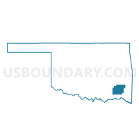
Voting District 9, Pushmataha County, Oklahoma
About
Outline

Summary
| Unique Area Identifier | 655101 |
| Name | Voting District 9 |
| County | Pushmataha County |
| State | Oklahoma |
| Area (square miles) | 128.19 |
| Land Area (square miles) | 127.51 |
| Water Area (square miles) | 0.67 |
| % of Land Area | 99.47 |
| % of Water Area | 0.53 |
| Latitude of the Internal Point | 34.50128380 |
| Longtitude of the Internal Point | -95.22265590 |
Maps


Graphs
Select a template below for downloading or customizing gragh for Voting District 9, Pushmataha County, Oklahoma


Neighbors
Neighoring Voting District (by Name) Neighboring Voting District on the Map
- Voting District 10, Pushmataha County, OK
- Voting District 15, Pushmataha County, OK
- Voting District 17, Pushmataha County, OK
- Voting District 19, Pushmataha County, OK
- Voting District 8, Pushmataha County, OK
Top 10 Neighboring County Subdivision (by Population) Neighboring County Subdivision on the Map
- North Pushmataha CCD, Pushmataha County, OK (3,033)
- Finley-Rattan CCD, Pushmataha County, OK (2,647)
Top 10 Neighboring Elementary School District (by Population) Neighboring Elementary School District on the Map
Top 10 Neighboring Unified School District (by Population) Neighboring Unified School District on the Map
- Antlers Public Schools, OK (5,759)
- Clayton Public Schools, OK (1,633)
- Battiest Public Schools, OK (1,394)